Understanding Cut, Fill, Net Volume, and Elevation Statistics in Drone Survey Data
What These Measurements Mean for Your Project
When you work with drone survey data, you will encounter terms like cut, fill, net volume, and elevation statistics. These concepts are central to understanding the terrain you are mapping and the changes that occur over time. Whether you are managing a construction site, monitoring a quarry, or planning a landscaping project, knowing how to interpret these numbers helps you make informed decisions without guesswork.
Drone survey data provides a detailed, three-dimensional picture of a site. By processing aerial images into point clouds and digital elevation models, surveyors can calculate volumes and elevations with remarkable precision. This article explains what each term means, how the calculations work in practice, and why they matter for your workflow.
Cut and Fill: The Basics
Cut and fill refer to the two main actions in earthmoving. Cut is the material removed from a site, while fill is the material added. In a typical construction project, you might need to lower a hill (cut) and use that soil to raise a low area (fill). The goal is often to balance these two quantities, so you do not have to import or export material, saving time and money.
Drone survey data makes this process transparent. By comparing two surveys of the same area taken at different times, software can calculate exactly how much material was cut or filled between them. This is called a volumetric comparison. The result is expressed in cubic meters or cubic yards, giving you a clear number to work with.
How Cut and Fill Are Calculated
The calculation starts with a digital terrain model (DTM) derived from your drone survey. The DTM represents the ground surface as a mesh of triangles or a grid of points. To find cut and fill volumes, the software compares this surface to a reference surface, usually the desired final grade or a previous survey.
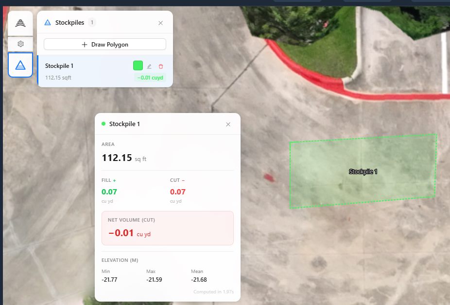
For each cell or triangle in the model, the software checks whether the current surface is above or below the reference. If it is above, that cell contributes to cut volume. If it is below, it contributes to fill. The volume for each cell is the area of the cell multiplied by the height difference. Summing all cells gives the total cut and fill volumes for the site.
Accuracy depends on the quality of the drone survey. Factors like ground control points, camera calibration, and flight overlap affect the point cloud density. A higher density means more detail and more reliable volume numbers. Most professional drone survey services, such as those offered through platforms like nationaldroneservices.net, ensure these parameters are met for consistent results.
Net Volume: The Bottom Line
Net volume is simply the difference between cut and fill. If you cut 500 cubic meters of material and fill 300 cubic meters, the net volume is 200 cubic meters of cut. That means you have 200 cubic meters of excess material that must be moved off site or stockpiled. If the net volume is negative, you have a deficit and need to import material.
Net volume gives you a quick health check on your earthwork budget. A project with a net volume near zero is balanced and efficient. A large net volume in either direction signals extra hauling costs and potential delays. Monitoring net volume over successive surveys lets you track progress and adjust plans early.
Elevation Statistics: Understanding the Terrain
Elevation statistics describe the shape of the ground. Common metrics include minimum elevation, maximum elevation, mean elevation, and standard deviation. These numbers help you characterize a site before you start moving earth.
Minimum and Maximum Elevation
The lowest and highest points on your site. These define the vertical range and are useful for spotting extreme features like deep gullies or tall embankments. They also help you set up your reference surface for cut and fill calculations.
Mean Elevation
The average height of all surveyed points. This is a simple reference value. If you are planning a flat final grade, the mean elevation gives you a starting point for the target surface.
Standard Deviation
This measures how much elevations vary across the site. A low standard deviation means the ground is relatively flat. A high value indicates rugged terrain with steep slopes and significant relief. Knowing this helps you choose the right survey parameters and anticipate challenges in earthmoving.
Elevation statistics are also used to detect change over time. By comparing the mean elevation of two surveys, you can see if the site is settling, eroding, or being built up. This is valuable for monitoring stockpiles, tailings dams, or landfill cells.
Practical Applications
These measurements are not just theoretical. They drive real decisions on site. For example, a civil engineer reviewing drone survey data for a road project will look at net volume to estimate the quantity of fill needed for embankments. A mine operator will track cut volumes to measure ore extraction. A landfill manager will monitor elevation changes to ensure compliance with permit limits.
Drone survey data also helps with inventory management. Stockpiles of gravel, topsoil, or ore can be measured regularly to update inventory counts. Instead of driving a truck over a scale, you fly a drone and get volume within minutes. The savings in time and labor are substantial.
Common Pitfalls and How to Avoid Them
Even with good data, mistakes can happen. One common error is using the wrong reference surface. If you compare a survey to an outdated design surface, the cut and fill numbers will be meaningless. Always verify that the reference matches the current project phase.
Another issue is vegetation. A drone survey captures the top of vegetation, not the bare ground. For volume calculations, you need a bare-earth model. This is achieved either by flying during leaf-off conditions or by using processing software that filters out vegetation. Some platforms, including those used by National Drone Services, offer automated vegetation removal, but it is worth checking that your data has been cleaned properly.
Ground control points (GCPs) are another critical factor. Without accurate GCPs, the survey may have a systematic elevation error. This error propagates into every volume calculation. Always ensure that GCPs are surveyed with high-accuracy GPS or total station equipment.
Integrating Drone Survey Data into Your Workflow
To get the most from these statistics, you need a reliable way to process and visualize your data. A platform like nationaldroneservices.net provides tools for uploading raw drone imagery, processing it into orthophotos and elevation models, and running volumetric analyses. The interface lets you compare multiple surveys side by side, export reports, and share results with stakeholders.
National Drone Services also offers nationwide capture services for teams that prefer to outsource the flying. This can be a good option if you lack a drone pilot license or need coverage of a large site. The data is delivered ready for analysis, so you can focus on interpretation rather than logistics.
Making Sense of the Numbers
Once you have your cut, fill, net volume, and elevation statistics, the next step is to turn them into action. For a balanced site, you might adjust the final grade to reduce net volume. For a site with excess cut, you might plan a stockpile area or coordinate with a nearby project that needs fill. The numbers give you a factual basis for these decisions, reducing the risk of costly surprises during construction.
Remember that drone survey data is only as good as the survey itself. Invest in proper flight planning, use ground control, and process with care. The effort pays off in reliable volumes that you can trust for billing, compliance, and project management.
By understanding cut, fill, net volume, and elevation statistics, you turn raw drone survey data into actionable intelligence. Whether you are a civil engineer, a mine surveyor, or a construction manager, these concepts are the foundation of effective earthwork management.
National Drone Services on social media
 Facebook